I think this is especially relevant to people who want to plan long distance flights: The wind isn't going to be blowing the same direction in the mountains at all places at all times throughout the flight. I noticed this when trying to plan a 500 km task in Condor and trying to use real-world conditions throughout the entire task area just using The Weather Network.
But there's a current, whole-world wind tracking site out there! Specifically designed for people who like sailing and wind surfing, windfinder.com provides real life conditions in real time, and does so for the entire world, apparently using weather satellite data.
Perhaps this is a crazy suggestion, but it's a suggestion nonetheless. Perhaps we can have a "use current date and weather" checkbox in the weather pane. Even though many of us would rather be using Condor during the not-ideal-weather days, and doing real flying on the ideal weather days.
Integration with Windfinder?

Re: Integration with Windfinder?
This is a nice idea.
at the time of condor1, I flew more with FSX glider because we could thanks to a meteo addon, take the weather history, or take the real weather to make a flight.
I took the historical weather on real flights, I had fun doing the flight simulator with the same condition of the day.
I went for example on the netcoupe, take an existing circuit such day and I redid it.
On condor it would be great, actually to have the MTO condition change during his flight.
-
MrHerisson
- Posts: 222
- Joined: Sat Mar 30, 2019 9:11 pm
Re: Integration with Windfinder?
I also used to fly FSX online with real weather option. I loved to go flying around my hometown during thunderstorms.
The severe conditions made it more difficult and more fun.
But in Condor, real weather would mean unflyable most of times....at least in my country. Plus the fact that I mostly play at night...mmm probably not the best conditions for thermals here.
I could add 100 hours of flight in a month on Condor but it took me 5 years to put in 200 hours of real life paramotors (weather, real life obligations, winter).
So having a real time weather could be fun but I don't think I would use it that much.
Also, I remember that "real time " was actually updated every 15 mins with sometimes abrupt changes in wind speed and direction. (i do remember breaking my wings at 30.000 ft because of a sudden wind change....).
That is something I definitely do not want to happen in C2.
On the other hand, I did a group flight where the taskmaker tweaked his weather settings untill he got it close to what he experiences IRL, and it was wonderful. Of course you need someone who flies there IRL.
Maybe a collection of "As Close As Real" weather settings (made by people who fly there) could be made available to the public.
Like a new category in the flightplan list on Condor Club.


Re: Integration with Windfinder?
IMHO, RW weather will be of almost of no use or to say, no benefit to condor flying.
On the other hand, adding RW weather phenomena (changing weather, wind shift, moving fronts, rain, thunderstorms and so on) into the existing weather model would be of great benefit.
On the other hand, adding RW weather phenomena (changing weather, wind shift, moving fronts, rain, thunderstorms and so on) into the existing weather model would be of great benefit.

Re: Integration with Windfinder?
I don't think 'real world weather' would be of great use compared to the likely effort to put in; as I assume most people who seriously use Condor are glider pilots themselves and would rather be flying for real on the good days.
I would like to see some changeable conditions though; the other week I flew a task of around 130km in a reasonably strong wind which would be pretty routine in Condor, and I could replicate it.
What made it particularly interesting in real life though was that the wind always wanted to push me toward some class A airspace - which I could replicate by drawing in on the task screen as a penalty zone, but that on the return leg, I had to cross a 20km blue hole that had been caused by the air flowing off a cold estuary. There were thermals in there but unmarked and actually I was saved by flying (randomly) through a strong core which just happened to have a couple of soaring birds turning in it to help me centre and climb away.
That's the kind of flight I would like to be able to replicate in Condor.
Re: Integration with Windfinder?
This happens in Condor too if the scenery has a good thermal map (black in the area that is cold and wet). It will create blue holes around lakes and sea if it is made propperly.KipperUK wrote: ↑Tue Jun 04, 2019 3:38 pmbut that on the return leg, I had to cross a 20km blue hole that had been caused by the air flowing off a cold estuary. There were thermals in there but unmarked and actually I was saved by flying (randomly) through a strong core which just happened to have a couple of soaring birds turning in it to help me centre and climb away.
That's the kind of flight I would like to be able to replicate in Condor.
PH-1504, KOE
Re: Integration with Windfinder?
That would require different thermal maps for different wind directions and strengths though; it could be quite nice if that happened dynamically - although I'm sure there'll be times when blue holes don't appear / do appear when you expect something different to happen due to other atmospheric conditions I am too clueless to explain!
Re: Integration with Windfinder?
Condor does this dynamicly. Thermals drift with the wind. I would suggest trying with the Matamata scenery. The big lake and the coast have an effect on thermals. The lee side of the lake, and the lake itself usually has a lot less thermals and may even be blue.
The TCC competition made great use of this in it's task setting.
The TCC competition made great use of this in it's task setting.
PH-1504, KOE
Re: Integration with Windfinder?
Can you confirm whether the thermal map contains an area of 'less thermic activity' on the lee side of the lake, and whether this is set up for the prevailing wind conditions or not?wickid wrote: ↑Tue Jun 04, 2019 11:43 pmCondor does this dynamicly. Thermals drift with the wind. I would suggest trying with the Matamata scenery. The big lake and the coast have an effect on thermals. The lee side of the lake, and the lake itself usually has a lot less thermals and may even be blue.
I could do that on my map for a prevailing westerly, but we can and do soar in any wind direction - even strong easterlies (which is what this day was) and as far as I can tell, that would require use of a different thermal map to denote areas where there would be less thermal activity.
Also, a fairly major point was that during my flight, the blue 'hole' wasn't flat - it obviously contained thermals (actually quite a good one!), just no thermal markers.
Re: Integration with Windfinder?
The thermal map just marks the area's that are likely/unlikely to develop thermals. In Matamata the lake area is set to black (0%) as far as I know. Condor then dynamically calculates the thermals. If you look at the videos on the website you will see how they develop and move with the wind. Here is a test I did with Matamata:

Wind from the top right corner. You can see on the upwind side of the lake some thermals being blown onto the water and dying. And on the lee side of the lake in the bottom left corner very little thermal development. (Some weak blue ones are there).
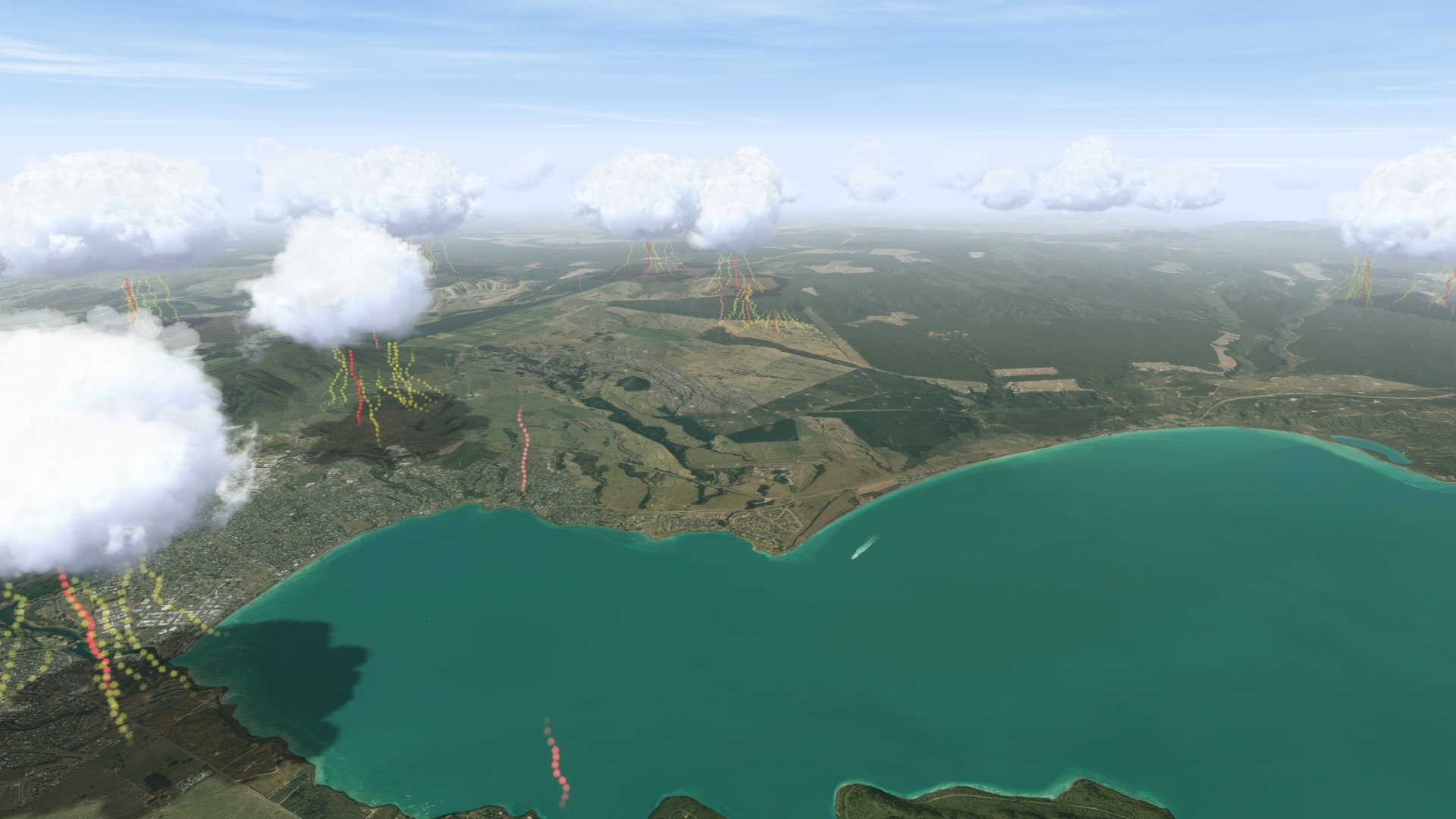
Now looking downwind. You see a bit of dead air in the lee of the lake. The town on the left is generating good thermals (probably white in the thermal map). The forest on the right is also not giving as many thermals, but the fields between the trees are.

Same weather settings, but the wind turned 180 degrees. Now the fields at the lakes edge are making good thermals. If you look the other way:

You can see that now the other side of the lake is blue. The thermals above the lake are blown by the wind off the upwind coast and will die over the lake. No new thermals are forming over the lake.
As you can see this is all done dynamically by Condor. What you need to do in the thermal map is just highlight the ground Albedo. So lakes, sea and snow need to be black (low chance of thermals), and big open fields, towns and industrial sites need to be white. And other terrain needs to be in between. Maybe EDB can explain a bit better what types of terrain need what colour. Mountain side thermals are also done dynamically by condor. So no need to highlight sunny slopes. The thermal map is just a map of what terrain type has the highest relative changes of a thermal. No need to take into account prevailing winds or stuff like that.
Wind from the top right corner. You can see on the upwind side of the lake some thermals being blown onto the water and dying. And on the lee side of the lake in the bottom left corner very little thermal development. (Some weak blue ones are there).
Now looking downwind. You see a bit of dead air in the lee of the lake. The town on the left is generating good thermals (probably white in the thermal map). The forest on the right is also not giving as many thermals, but the fields between the trees are.
Same weather settings, but the wind turned 180 degrees. Now the fields at the lakes edge are making good thermals. If you look the other way:
You can see that now the other side of the lake is blue. The thermals above the lake are blown by the wind off the upwind coast and will die over the lake. No new thermals are forming over the lake.
As you can see this is all done dynamically by Condor. What you need to do in the thermal map is just highlight the ground Albedo. So lakes, sea and snow need to be black (low chance of thermals), and big open fields, towns and industrial sites need to be white. And other terrain needs to be in between. Maybe EDB can explain a bit better what types of terrain need what colour. Mountain side thermals are also done dynamically by condor. So no need to highlight sunny slopes. The thermal map is just a map of what terrain type has the highest relative changes of a thermal. No need to take into account prevailing winds or stuff like that.
PH-1504, KOE
Re: Integration with Windfinder?
Yep, I understand about the thermal map - although I didn't know that they thermals that blew over the water would be killed by it.
Reading your post though, I guess I will have to try it out to see how far the effect goes; the real flight took place in an easterly of about 25kt at height and the effect was to create a blue area that was probably 20km x 20km if not a bit more than that.
As I said, there were thermals within it, just no cumulus. I will give it a go and see how well it works.
I had forgotten that I had a thermal map which should prevent new thermals being formed over the water, but I am interested to see how far the effect spreads and whether it develops a significant dead zone.

Re: Integration with Windfinder?
I guess your flight was in the UK. Please note that North UK, West UK and South East UK Condor 2 sceneries do not have an accurate thermal map.
You can of course make your own version of the scenery with a correct albedo thermal map.
The recently released Scotland 4 does have a correct albedo thermal map.
West-UK2 will shortly (within 2 weeks) be released via CC with also a correct albedo thermal.
Next on my list of correcting my earlier shortcomings will be North UK2 (with correct thermal map, trees, water effects and 3d objects).
It will take some time, scenery building is very time consuming.
Condor CN = E20
Re: Integration with Windfinder?
I've got my own version of North UK with an approximate thermal map; with definite marked areas of water. I'm still working on the trees, but plan to submit it somehow/somewhere so that other people can use it.
I gave it a little test last night with a howling ESE'ly wind and taking off from Burn GC, there was indeed a big blue area coming off the Humber, hard to see how far it went and what the 'overall' sky looked like from my test, but it was promising.
I guess there would have been no 'blue' thermals in there though?
