Using the modified technique, I get the following for your soaring area, which covers Netherlands. I think it is correct!
GUI based Photorealistic Condor Scenery Tutorial - draft
Re: GUI based Photorealistic Condor Scenery Tutorial - draft
You do not have the required permissions to view the files attached to this post.
-
Jan Oorthuijsen

- Posts: 491
- Joined: Sat Jul 02, 2005 4:27 pm
- Location: Utrecht (Terwijde) - Holland
Re: GUI based Photorealistic Condor Scenery Tutorial - draft
Hi Tom,
As expected the latitude needs correction .2073. Then the tiles are not squares anymore. I rest my case.
Grtz Jan
As expected the latitude needs correction .2073. Then the tiles are not squares anymore. I rest my case.
Grtz Jan
You do not have the required permissions to view the files attached to this post.
PH-722
WW
It’s Difficult to Soar Like An Eagle
When You’re surrounded By Turkeys
WW
It’s Difficult to Soar Like An Eagle
When You’re surrounded By Turkeys
Re: GUI based Photorealistic Condor Scenery Tutorial - draft
Jan, I've update the spreadsheet and want to confirm it is now calculating both X and Y axis properly. Can you look at the scenery boundaries in cells J29/K29 through J32/K32 and confirm if they are correct now with a 12 X 14 terragen tile size?
You can see I added J16/K16 to correct the X/Y decimal degrees per terragen tile in each dimension. Also, I converted those to the correct X/Y pixel size in J25/K25.
I think I'll have to alter the steps in the tutorial that build a point grid since it doesn't allow for differing vertical and horizontal degree sizes. I'll probably alter the Calibration Points tab to calculate the points and then import them into QGIS rather than generate and export them.
You do not have the required permissions to view the files attached to this post.
Re: GUI based Photorealistic Condor Scenery Tutorial - draft
Hi, Tom.
After 7 months I decide to try again to work on my scenary (Ipua, near Caçapava, SP, Brazil). I've got a copy of the 0.99 version of the scpreadsheet, and just for testing I choose a 3 terragens x 1 terragen scenery (longitude x latitude), but the the calibration points result in a 1x3 (latitude x longitude). Somehow X and Y, longitude and latitude have been swapped.
Thanks again for your work.
Mauricio
You do not have the required permissions to view the files attached to this post.
Re: GUI based Photorealistic Condor Scenery Tutorial - draft
Thanks for the heads up. You can fix the problem when you cut and paste to Notepad. Just reverse the words Latitude and Longitude and make sure the commas are correct.
Re: GUI based Photorealistic Condor Scenery Tutorial - draft
Yes, I figure it out, but it must reverse the letters Y and X too (X,Y,Latitude,Longitude).
Thanks.
Mauricio
Thanks.
Mauricio
tberry wrote:Thanks for the heads up. You can fix the problem when you cut and paste to Notepad. Just reverse the words Latitude and Longitude and make sure the commas are correct.
-
tangoeight
- Posts: 9
- Joined: Sun Nov 20, 2016 6:16 pm
Re: GUI based Photorealistic Condor Scenery Tutorial - draft
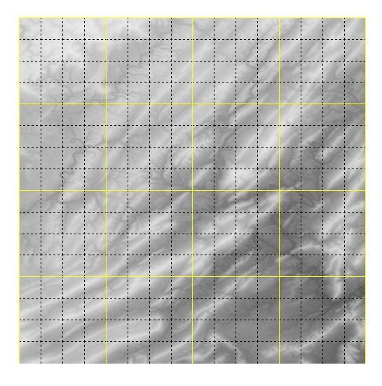
I have a 1024 x 1024 .trn file that I've loaded into the landscape editor and it looks like this -- no yellow border at bottom. Is this is a problem? If it is, as Tom's tutorial suggests, how would I fix this?

Re: GUI based Photorealistic Condor Scenery Tutorial - draft
That looks correct to me. Each one is 4x4.
Don't know why the yellow doesn't show, but it should be okay as long as that last row doesn't keep going with, say, 5 rows.
Don't know why the yellow doesn't show, but it should be okay as long as that last row doesn't keep going with, say, 5 rows.
Re: GUI based Photorealistic Condor Scenery Tutorial - draft
Hi Tangoheight,
Do not worry!
There is no yellow bottom line in Landscape Editor for every sceneries.
Have a look to another scenery.
Good continuation !
Do not worry!
There is no yellow bottom line in Landscape Editor for every sceneries.
Have a look to another scenery.
Good continuation !
*****- Xavier - (XDL - VR FAN) *****
-
tangoeight
- Posts: 9
- Joined: Sun Nov 20, 2016 6:16 pm
Re: GUI based Photorealistic Condor Scenery Tutorial - draft
Thanks for replies! I'll continue then.
-
tangoeight
- Posts: 9
- Joined: Sun Nov 20, 2016 6:16 pm
Re: GUI based Photorealistic Condor Scenery Tutorial - draft
After some screwing around... I got the BDA running, accessed my orders for NAIP JPG 2000 files. Unfortunately all of the files currently show as "unavailable". Is this a congestion issue and likely to resolve itself?
update: I got a response to my query with USGS stating that there had been a problem with bulk d/l. It's fixed now.
update: I got a response to my query with USGS stating that there had been a problem with bulk d/l. It's fixed now.
-
tangoeight
- Posts: 9
- Joined: Sun Nov 20, 2016 6:16 pm
Re: GUI based Photorealistic Condor Scenery Tutorial - draft
Argh. The routines on the tile cutting page of the spreadsheet (1.0) don't work for me. I got output files, I got a little bit of imagery (right scene at more or less right location) but most of it (90%) was black. I used the OSGEO4W shell.
I've verified that I have all the .jp2 files I need (loaded into QGIS, they completely tile the area of interest).
I was hoping this was a cookbook method. I don't know nearly enough about these resources and tools to troubleshoot.
update: The purple shaded area is the size of the scenery. The tiny little smudge is the part of the .jp2 imagery that has been (successfully?) processed. I've overlaid this with my SRTM elevation data and as far as I can tell, the images are correctly located and scaled.
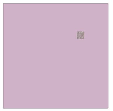

Re: GUI based Photorealistic Condor Scenery Tutorial - draft
I've never seen this problem before at this scale. I've had black areas in my sceneries but that was due to either missing scenery tiles (you verified that you have all of the proper ones already) or because i erred in putting in the boundaries of the scenery. The spreadsheet entries should prevent that problem, though.
One thought I have is that you have the scenery tiles located in different folders. They MUST all be in the SAME folder. No sub-folders.
Also, be sure that the path to that folder is set properly in the tile cutting tab of the worksheet.
One thought I have is that you have the scenery tiles located in different folders. They MUST all be in the SAME folder. No sub-folders.
Also, be sure that the path to that folder is set properly in the tile cutting tab of the worksheet.

Re: GUI based Photorealistic Condor Scenery Tutorial - draft
Whenever I try to download the spreadsheet I get an error which I try to start the spreadsheet I get this:
Removed Records: Formula from /xl/worksheets/sheet2.xml part
The result is that the 'calibration points' part of the spreadsheet does not work which prevents me from developing a scenery using this tool.
Can anyone help with download link that works or what needs to be corrected in the SS to make the calibration work?
Condor CN = E20
Re: GUI based Photorealistic Condor Scenery Tutorial - draft
Use the Google Sheets version, not the excel file. I should remove that from the links. There are slight incompatibilities between the online and Excel version, even if you simply download the Google Sheet to your Excel file. Instead, just use an online version of the sheet.
